Sierra Nevada
Mist Trail Guide: Hiking to Vernal and Nevada Falls
How to hike Yosemite’s Mist Trail to Vernal and Nevada Falls: distances, the granite steps, parking and shuttles, the best season and what to pack.

By Alex Khachigian · Updated September 2026 · 3 min read
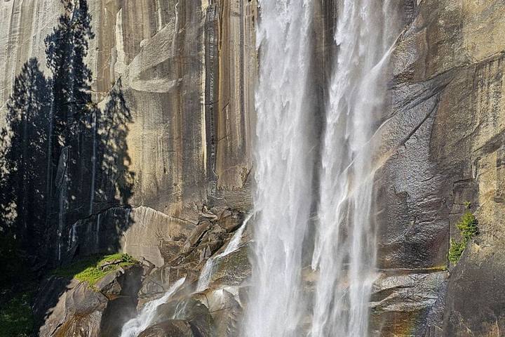
Yosemite’s Mist Trail climbs granite steps beside 317-foot Vernal Fall and continues to 594-foot Nevada Fall. I filmed a reel breaking it down step by step.
This guide covers distances, trailhead access, seasons and packing. For more options, see my best day hikes in Yosemite.
In This Guide
- Mist Trail Distances: Three Ways to Hike It
- Getting to the Happy Isles Trailhead
- Happy Isles to the Vernal Fall Footbridge
- Climbing the Mist Trail Steps to Vernal Fall
- Continuing to the Top of Nevada Fall
- Best Time to Hike the Mist Trail
- What to Pack for the Mist Trail
- Mist Trail Safety and Leave No Trace
- FAQ
Mist Trail Distances: Three Ways to Hike It
The trail starts at Happy Isles in eastern Yosemite Valley. Choose a turnaround point on the trail.
- Vernal Fall footbridge: about 1.6 miles round trip, moderate but steep
- Top of Vernal Fall: about 2.4 miles round trip, strenuous stairs
- Top of Nevada Fall: about 5.4 miles round trip, or 6 to 7 miles down the John Muir Trail
- Elevation gain: about 1,000 feet to Vernal, 2,000 feet to Nevada
Getting to the Happy Isles Trailhead
Happy Isles is stop 16 on the free Valleywide Shuttle, which runs every 12 to 22 minutes from about 7 am to 10 pm. There’s no trailhead parking.
Park at the Trailhead Parking lot near Curry Village and walk about half a mile, or take the shuttle. Summer weekend lots fill by mid-morning.
Happy Isles to the Vernal Fall Footbridge
A steep paved path climbs 0.75 miles to the footbridge, with restrooms and a summer fountain. Many families turn around here.
Climbing the Mist Trail Steps to Vernal Fall
The next half mile climbs more than 600 granite steps beside Vernal Fall. In spring and early summer they’re wet and slick; use the handrails near the top.
The top is a granite ledge beside the fall, with the Emerald Pool upstream. Many hikers turn around here.
Rainbows and Rain Gear
Rainbows form in the spray on sunny mornings. Bring a rain jacket in spring and early summer, and a zip bag for your phone.
Continuing to the Top of Nevada Fall
From Vernal, it’s another 1.3 miles of switchbacks to the top of Nevada Fall, with Liberty Cap beside it. A footbridge crosses the river above the brink.
Return the same way or take the John Muir Trail down.
Best Time to Hike the Mist Trail
Late April through June has the most water. In winter the steep section often closes for ice, and hikers use the John Muir Trail.
- Spring: biggest falls, heavy spray, slippery steps
- Summer: warm and busy, falls shrinking by August
- Fall: quieter, little water
- Winter: steps often closed, use the John Muir Trail
What to Pack for the Mist Trail
The trail is steep and wet, so shoes and water matter most.
- Shoes with solid grip for wet granite
- Rain jacket or poncho in spring and early summer
- At least 2 liters of water per person, more for Nevada Fall
- Snacks, sunscreen and a hat
- Waterproof case or zip bag for your phone
Mist Trail Safety and Leave No Trace
Stay on the trail and behind railings near both falls. Most accidents involve people climbing past barriers or wading near the brink.
Feeding squirrels is illegal. Pack out all trash, including fruit peels.
Frequently Asked Questions
How long does the Mist Trail take?
About 2 to 3 hours round trip to the top of Vernal Fall and 5 to 6 hours to the top of Nevada Fall.
Is the Mist Trail hard?
It’s short but strenuous because of the steep steps. Most people in decent shape can reach the top of Vernal Fall.
Do you need a permit to hike the Mist Trail?
No permit is needed for a day hike. A park entry reservation may be required in busy periods; check NPS.gov.
Is the Mist Trail open in winter?
The steep section beside Vernal Fall is often closed for ice. The John Muir Trail is the alternate route.
How tall are Vernal Fall and Nevada Fall?
Vernal Fall drops 317 feet and Nevada Fall drops 594 feet. Both peak in late spring.
Destination guide
My Yosemite hotel, Airbnb and tour picks