Sierra Nevada
Eastern Sierra Fall Colors: Where and When to Go
Eastern Sierra fall colors: when the aspens peak, the best canyons from Bishop Creek to Lundy, a 3-day Highway 395 route, and where to stay along the way.

By Alex Khachigian · Updated September 2026 · 3 min read
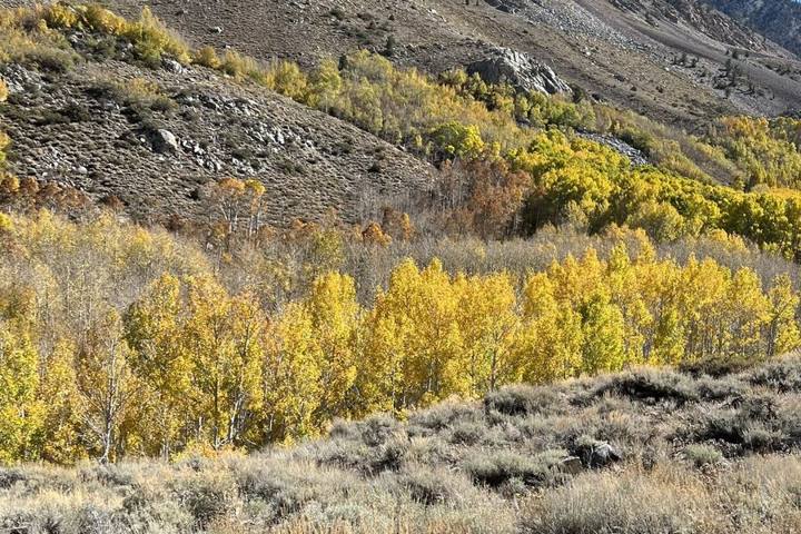
Aspens along Highway 395 turn from late September to late October, moving downhill over about a month.
Convict Lake, June Lake and Bishop Creek were on my 35-stop Highway 395 list. See my 7-day Highway 395 itinerary.
In This Guide
- When Do Eastern Sierra Fall Colors Peak?
- Bishop Creek Canyon Fall Colors
- Rock Creek, McGee Creek and Convict Lake
- June Lake Loop Fall Colors
- Lundy Canyon, Conway Summit and Virginia Lakes
- 3-Day Eastern Sierra Fall Color Road Trip
- Where to Stay for Fall Colors on Highway 395
- Photographing Aspens and Fall Color Etiquette
- FAQ
When Do Eastern Sierra Fall Colors Peak?
Color runs late September to late October. Lakes above 9,000 feet in upper Bishop Creek peak first, in late September or early October.
The June Lake Loop peaks early to mid October; lower slopes last into late October.
Bishop Creek Canyon Fall Colors
Bishop Creek Canyon, west of Bishop on Highway 168, climbs into aspens and splits toward North Lake, Lake Sabrina and South Lake, all above 9,000 feet.
North Lake
North Lake is the most photographed spot. The last stretch is narrow dirt with little parking, so go at sunrise or midweek.
Lake Sabrina and South Lake
Lake Sabrina is easy to reach via Aspendell. South Lake Road follows Bishop Creek.
Rock Creek, McGee Creek and Convict Lake
These three canyons between Bishop and Mammoth are just off Highway 395 and doable in a day.
Rock Creek Canyon
Rock Creek Road climbs past 10,000 feet to Mosquito Flat.
McGee Creek Canyon
The first mile or two of the McGee Creek trail is easy.
Convict Lake
Convict Lake has aspens at the inlet end and a flat 2.5 mile loop.
June Lake Loop Fall Colors
The June Lake Loop (Highway 158) is a 16 mile loop past June, Gull, Silver and Grant lakes, peaking early to mid October.
Stop at Gull Lake, Silver Lake and the Parker Lake Trail.
Lundy Canyon, Conway Summit and Virginia Lakes
North of Mono Lake, Lundy Canyon has a trail past aspens and beaver ponds.
Conway Summit, about 8,140 feet, is the highest point on Highway 395.
- Lundy Canyon: easy trail past beaver ponds
- Conway Summit: turnouts on 395
- Virginia Lakes: often an early peak
- Farther north: Monitor Pass (Highway 89) and Hope Valley (Highway 88) near Tahoe
3-Day Eastern Sierra Fall Color Road Trip
Drives between canyons are 20 to 45 minutes, with little backtracking.
- Day 1: Bishop, lunch at Erick Schat’s Bakkerÿ, then Lake Sabrina and South Lake. Sleep in Bishop or Aspendell.
- Day 2: Sunrise at North Lake, then Rock Creek, McGee Creek and late afternoon at Convict Lake. Sleep in Mammoth Lakes.
- Day 3: June Lake Loop, lunch at the Whoa Nellie Deli in Lee Vining, then Lundy Canyon and Conway Summit.
Where to Stay for Fall Colors on Highway 395
Book 1 to 2 months ahead for October weekends. Several lakeside resorts close mid to late October, so confirm dates.
Try Cardinal Village Resort in Aspendell, the Creekside Inn in Bishop, or Tamarack Lodge and The Village Lodge in Mammoth. See my Mammoth and June Lake cabin guide.
Photographing Aspens and Fall Color Etiquette
Shoot backlit aspens early or late, with a polarizer.
Park fully off the road and don’t block driveways. Never carve aspen bark, and stay on trails.
Frequently Asked Questions
When is peak fall color in the Eastern Sierra?
From late September at the highest lakes to late October lower down. Early to mid October is the safest bet.
Where is the best fall foliage in California?
The Eastern Sierra: Bishop Creek Canyon, the June Lake Loop, Lundy Canyon and Conway Summit. Hope Valley and Monitor Pass near Tahoe are also good.
Is Tioga Pass open in the fall?
Usually through much of October, but it closes with the first major snow. Check nps.gov/yose and Caltrans QuickMap.
How long does fall color last in the Eastern Sierra?
About a month overall, but one grove peaks for a week or two. Wind or storms can end it sooner.
Do I need a four-wheel drive for the fall color canyons?
No. The main canyon roads are paved or easy dirt, and the gravel stretch to North Lake is fine for most cars when dry.
Destination guide
My Mammoth hotel, Airbnb and tour picks