Northern California
Lost Coast Trail Guide: Permits, Tides and Gear
Plan the Lost Coast Trail: King Range permits on Recreation.gov, tide charts for the impassable zones, required bear canisters, shuttles and a 3-day plan.

By Alex Khachigian · Updated September 2026 · 3 min read
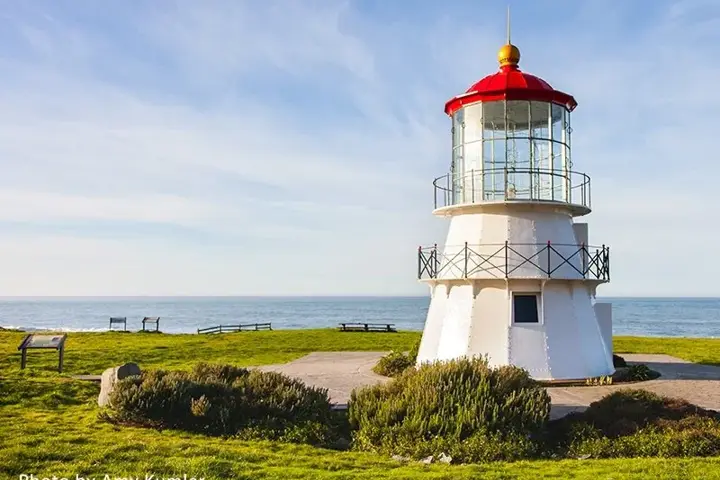
The northern Lost Coast Trail follows roughly 25 miles of beach through the King Range National Conservation Area, the longest undeveloped stretch of California coast.
This guide covers permits, bear canisters, tides, shuttles, a 3-day itinerary and gear.
In This Guide
Where the Lost Coast Trail Is
The trail runs from the Mattole Trailhead south to Black Sands Beach in Shelter Cove, in southern Humboldt County. The King Range is managed by the Bureau of Land Management.
Most hikers go north to south with the wind behind them. Expect 1 to 1.5 miles per hour on sand and cobbles.
The Sinkyone Section
South of Shelter Cove, the trail continues through Sinkyone Wilderness State Park, with more climbing and separate State Parks camping rules. This guide covers the King Range section.
Neither section has services or reliable cell coverage. For nearby redwoods and towns, see the Northern California coast road trip.
Lost Coast Trail Permits on Recreation.gov
Overnight trips in the King Range Wilderness need a permit from Recreation.gov. A quota applies roughly late spring through mid-September, and summer weekends go fast.
Permits cover a start date and group size. Check the BLM King Range page for release dates, group limits and fire restrictions.
Lost Coast Tides and Impassable Zones
Three sections on the BLM map run below cliffs and are impassable at high tide. Waves can trap or sweep hikers there.
The first and longest zone starts just past Punta Gorda Lighthouse. Cross only at low tide, using a printed Shelter Cove tide chart.
- Print a tide chart and the BLM map
- Arrive at each zone on a falling tide
- Never race an incoming tide or climb around cliffs
- Watch for sneaker waves
Bear Canisters on the Lost Coast
Approved bear canisters are required for all King Range overnight trips. Store all food, trash and scented items in it, away from your tent.
Local rentals are limited, so bring your own. The California bear safety guide covers approved models.
Lost Coast Shuttles, Parking and Getting There
Most people park at Black Sands Beach and shuttle to the Mattole Trailhead, about 2 to 3 hours on winding roads.
Permitted shuttles run from Shelter Cove and Garberville. Book ahead for summer.
Where to Stay Before the Hike
Garberville is the last town on US-101; the Benbow Historic Inn is just south. The BLM’s Mattole Campground is first-come at the trailhead; see the car camping guide.
A 3-Day Lost Coast Trail Itinerary
Most hikers take 3 days; 4 allows slack for tides and weather.
- Day 1: Mattole Trailhead past Punta Gorda Lighthouse; camp near Cooskie Creek or Spanish Flat
- Day 2: Camp at Big Flat, with a creek and wide beach
- Day 3: Past Shipman Creek and Buck Creek to Black Sands Beach
Lost Coast Gear and Safety
Weather swings between sun, fog and rain. Treat all creek water.
There is no cell service on most of the trail; carry a satellite messenger. Watch for ticks, poison oak and rattlesnakes, pack out trash and bury waste away from water.
- Bear canister
- Printed tide chart and BLM map
- Water filter or treatment
- Rain jacket and warm layers
- Boots or trail shoes, gaiters for sand
- Satellite messenger
- Trekking poles
Best Time to Hike the Lost Coast Trail
The season runs about May to October. Summer is often foggy; September and October are often clearer.
Winter brings rain, high surf and swollen creeks.
Frequently Asked Questions
Do you need a permit for the Lost Coast Trail?
Yes, for overnight trips, from Recreation.gov. A quota applies in the busy season.
How long does it take to hike the Lost Coast Trail?
Most take 3 days for the roughly 25 miles. Some take 4.
Are bear canisters required on the Lost Coast?
Yes, for all overnight trips in the King Range.
What are the impassable zones on the Lost Coast Trail?
Three sections that flood at high tide. Cross only at low tide with a tide chart.
Can you day hike the Lost Coast?
Yes, with no permit. Walk north from Black Sands Beach or south from the Mattole Trailhead toward Punta Gorda Lighthouse, and check tides.
How do shuttles work for the Lost Coast Trail?
Park at Black Sands Beach and take a permitted shuttle to the Mattole Trailhead, 2 to 3 hours away. Book early for summer.
Destination guide
My Humboldt County hotel, Airbnb and tour picks